


Plus d'actualité États-Unis


Europe Today
L'émission phare du matin d'Euronews avec les actualités et les analyses qui influencent l'Europe, en direct de Bruxelles chaque matin à 08h00. Également disponible sous forme de newsletter et de podcast.

The Ring
'The Ring' est l'émission de confrontation politique hebdomadaire d'Euronews, où les débats les plus animés d'Europe rencontrent les voix les plus franches. Dans chaque épisode, deux poids lourds de la politique européenne s'affrontent pour proposer une diversité d'opinions et susciter des conversations autour des questions les plus importantes concernant les affaires européennes.

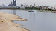
Water Matters
En Europe, l'eau est soumise à une pression accrue. La pollution, les sécheresses et les inondations menacent notre eau potable, nos lacs, nos rivières et nos côtes. Retrouvez-nous pour un tour d’horizon en Europe, pour comprendre pourquoi la protection des écosystèmes est cruciale, comment nos eaux usées peuvent être mieux gérées, et pour découvrir des solutions pour l'eau qui comptent parmi les plus efficaces. Des reportages vidéo, une série d'explications animées et un débat en direct - découvrez pourquoi l'eau compte autant, sur Euronews.

Climate Now
Nous vous présentons les dernières données climatiques à partir des principales sources mondiales. Nous analysons les tendances et expliquons l‘évolution de notre planète en rencontrant des experts qui cherchent de nouvelles stratégies pour atténuer le changement climatique.